
- 181 Views
- 9 Min Read
- (0) Comment
TL;DR:
- Kibale National Park’s total area is approximately 795 km² including its biological corridor.
- The park hosts over 13 primate species and 375 bird species, making it highly biodiverse.
- Accurate boundary data is essential for reliable ecological research and effective conservation planning.
Kibale National Park’s spatial extent has long been a source of genuine confusion in conservation literature. Some academic sources cite 766 km², others report 776 km², and the most complete figure reaches 795 km². This is not a trivial discrepancy. When researchers calculate population densities, carrying capacities, or habitat fragmentation indices, even a 1% variance in area data can shift conclusions meaningfully. Kibale covers approximately 766 km² in its core forest reserve, but the total spatial extent including a biological corridor connecting to Queen Elizabeth National Park brings the figure to 795 km². Understanding which number applies to your study is foundational to sound ecological analysis.
Table of Contents
- Defining Kibale National Park’s surface area
- Biodiversity overview: What makes Kibale special?
- Ecological significance and research applications
- Conservation challenges and the future of biodiversity in Kibale
- A researcher’s take: Why precision matters in ecological analytics
- Explore Kibale National Park with expert-led tours
- Frequently asked questions
Key Takeaways
| Point | Details |
|---|---|
| Varied park measurements | Kibale’s reported size ranges from 766 to 795 km² depending on the source. |
| Biodiversity hotspot | The park is renowned for its remarkable primate and avian diversity. |
| Precision impacts research | Accurate area figures are essential for reliable ecological analysis and management. |
| Conservation strategy | Detailed spatial knowledge enables targeted and effective park protection. |
Defining Kibale National Park’s surface area
With the stage set, it is vital to establish the actual geographical parameters of Kibale National Park before examining its ecological wealth.
Kibale was originally gazetted as a forest reserve in 1932 and formally designated as a national park in 1993. This gazettement history matters because boundary revisions occurred across decades, and older maps do not always reflect current protected area limits. The park sits at elevations ranging from 1,100 meters to 1,600 meters near Fort Portal in western Uganda, a gradient that directly shapes its mosaic of moist evergreen forest, woodland, and swamp.
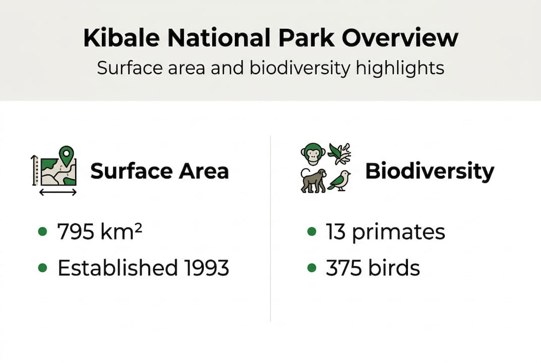
The most defensible total figure is 795 km², comprising a core forest reserve of 766 km² and an additional 29 km² biological corridor linking the park to Queen Elizabeth National Park. Area figures vary from 766 to 795 km² depending on whether authors include this corridor in their calculations.
| Source type | Reported area | Notes |
|---|---|---|
| Core forest reserve only | 766 km² | Most commonly cited in primate studies |
| Including biological corridor | 795 km² | Total protected spatial extent |
| Intermediate estimates | 776 km² | Likely partial corridor inclusion |
“The total spatial extent of Kibale National Park, including its biological corridor to Queen Elizabeth National Park, is 795 km², with the core forest reserve accounting for 766 km².”
Common reasons for discrepancies include:
- Differences in GIS mapping technology and resolution across survey periods
- Inconsistent inclusion or exclusion of buffer zones and corridors
- Boundary adjustments during the 1993 gazettement process
- Varied interpretation of what constitutes the “protected area” in meta-analyses
For conservation planning, using the wrong figure can misallocate ranger patrol zones, skew habitat connectivity models, and underestimate the ecological value of the corridor. Researchers planning field studies or policy reviews should clarify which measurement applies before designing sampling frameworks. A Kibale tracking safari gives field researchers direct exposure to the corridor terrain, which is often underrepresented in desk-based studies.
Biodiversity overview: What makes Kibale special?
Armed with the park’s physical boundaries, the next focus is the living richness that fills its forests and swamps.
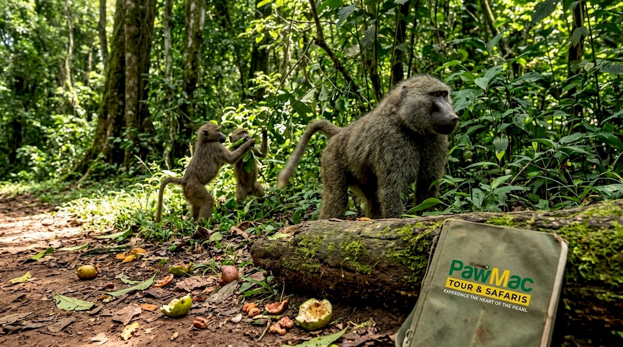
Kibale is renowned for high primate diversity, hosting at least 13 primate species within its forest matrix. This density is exceptional even by East African standards. The park’s moist evergreen canopy supports overlapping home ranges for species that rarely coexist at such concentrations elsewhere.

Plan Your Uganda Safari with Local Experts
| Metric | Kibale National Park | Bwindi Impenetrable Forest | Gombe Stream (Tanzania) |
|---|---|---|---|
| Primate species | 13+ | 11 | 8 |
| Bird species | 375+ | 350+ | 200+ |
| Flagship primate | Eastern chimpanzee | Mountain gorilla | Eastern chimpanzee |
Key primate species studied in Kibale include Eastern chimpanzees (Pan troglodytes schweinfurthii), red colobus (Piliocolobus tephrosceles), L’Hoest’s monkey (Allochrocebus lhoesti), red-tailed monkey, olive baboon, and black-and-white colobus. The red colobus population here is among the most studied in Africa, offering decades of longitudinal behavioral data.
Flora supporting this biodiversity includes:
- Ficus species (critical fruiting trees sustaining chimpanzee diets)
- Chrysophyllum albidum (a canopy species supporting frugivore communities)
- Markhamia lutea (important for nest-building primates)
- Papyrus (Cyperus papyrus) in Bigodi Wetland Sanctuary adjacent to the park
- Macaranga and Musanga pioneer species in regenerating forest patches
For Uganda primate tracking research, Kibale’s avifauna adds another layer of value. Over 375 bird species have been recorded, including the African pitta and the green-breasted pitta, making it a priority site for bird watching in Uganda alongside primate studies.
Pro Tip: Schedule field observations between 6:00 and 9:00 a.m. Primate activity peaks in the early morning hours, and light conditions in the forest understory are most favorable for behavioral recording and photography during this window.
Ecological significance and research applications
Beyond cataloging biodiversity, the park’s measurements drive practical scientific and conservation applications.
Accurate spatial extent data is the backbone of population ecology. Precise park area data is vital for calculating density, modeling species distribution, and detecting population trends over time. Without a consistent area figure, density estimates for the same chimpanzee population can differ by several individuals per square kilometer, a gap that matters when assessing whether a population is stable, growing, or declining.
Research enabled by reliable boundary data includes:
- Home range analysis using GPS collar data calibrated against park limits
- Habitat suitability modeling for red colobus and other range-restricted primates
- Disease transmission studies requiring accurate host population density inputs
- Long-term phenology monitoring tied to spatial vegetation maps
- Corridor usage studies tracking movement between Kibale and Queen Elizabeth National Park
Estimated population highlight: Kibale supports over 1,500 Eastern chimpanzees, one of the largest protected populations of this subspecies anywhere in Africa. This figure, combined with the park’s 795 km² extent, yields a mean density of roughly 1.9 chimpanzees per km², though actual distribution is highly uneven across habitat types.
For field researchers, understanding chimpanzee tracking success rates within Kibale also informs study design. Habituation status of focal groups, ranging patterns, and seasonal fruit availability all interact with the park’s spatial structure in ways that require precise geographic reference points.
Carrying capacity models, which estimate the maximum population a habitat can sustain, are directly sensitive to area inputs. A 29 km² difference between the core-only and total-extent figures translates to measurable shifts in these models, particularly for species with large home ranges like chimpanzees.
Conservation challenges and the future of biodiversity in Kibale
As we contemplate the science, it is essential to address the direct conservation realities facing Kibale.
Kibale’s ecological integrity faces persistent pressure from multiple directions. Data-driven decisions are key to effective biodiversity protection, and that starts with knowing exactly what area is being managed.
Main conservation challenges include:
- Agricultural encroachment: Smallholder farming along park boundaries reduces effective habitat and increases human-wildlife conflict
- Illegal hunting: Snares set for bushmeat incidentally injure chimpanzees and other primates
- Climate variability: Shifting rainfall patterns affect fruiting phenology, which cascades into primate nutrition and reproductive success
- Disease spillover: Proximity of human settlements increases risk of respiratory illness transmission to chimpanzee populations
- Corridor degradation: The 29 km² biological corridor linking Kibale to Queen Elizabeth National Park faces land-use pressure that threatens wildlife movement
Community engagement is not optional in this context. Buffer zone programs that provide economic incentives to neighboring communities have demonstrated measurable reductions in encroachment rates. Precise spatial data improves the targeting of these interventions by identifying which boundary segments face the highest pressure.
For Uganda safari tours that incorporate research components, community-based monitoring programs offer a practical entry point. Local field assistants trained in data collection contribute meaningfully to long-term datasets while building conservation awareness within their communities.
Pro Tip: When sourcing current population or boundary data for publications, prioritize collaboration with Uganda Wildlife Authority (UWA) and active NGOs such as the Kibale Chimpanzee Project. Published figures in secondary sources often lag field realities by several years.
A researcher’s take: Why precision matters in ecological analytics
This discussion would not be complete without stepping back to examine the implications of our measurements and assumptions.
The tendency in meta-analyses is to accept published area figures without scrutiny. Kibale is a clear example of why that habit is risky. A study using 766 km² and another using 795 km² are not analyzing the same landscape, even if both claim to study “Kibale National Park.” The biological corridor is not a marginal strip of scrub. It is functional habitat used by chimpanzees, elephants, and forest birds moving between two major protected areas.
“The margin of error in mapping can redefine research conclusions.”
When you build density estimates, fragmentation indices, or connectivity models on an incorrect area baseline, every downstream calculation inherits that error. This is especially consequential in comparative studies across parks or in IUCN assessments where population viability thresholds are area-dependent.
For researchers planning work in Kibale, a Uganda primate safari that includes time in both the core forest and the corridor zone offers ground-truth perspective that no map can fully replace. Seeing the corridor terrain firsthand sharpens your understanding of what those 29 km² actually represent ecologically.
Do not take published figures at face value. Contact UWA directly, review the General Management Plan, and clarify boundary definitions before finalizing your study design.
Explore Kibale National Park with expert-led tours
Moving from theory to practice, expert-led field experiences can deepen your insights and strengthen your conservation impact in ways that desk research alone cannot achieve.

PawMac Safaris offers guided access to Kibale’s core forest and its biological corridor, giving researchers and ecological enthusiasts direct exposure to the habitats behind the numbers. Whether your focus is primate behavioral observation, avifauna surveys, or habitat assessment, our Uganda safari experiences are structured to support serious inquiry alongside immersive wildlife engagement. Browse our full range of best wildlife tours to find the itinerary that aligns with your research objectives and timeline.
Frequently asked questions
How big is Kibale National Park, and why do some sources report different sizes?
Kibale’s area varies in literature because some sources cite only the core forest reserve at 766 km², while the complete spatial extent including the biological corridor to Queen Elizabeth National Park reaches 795 km².
What makes Kibale a significant site for biodiversity research?
Kibale is renowned for primate diversity with over 13 species present, combined with 375+ bird species and decades of longitudinal behavioral datasets that make it one of Africa’s most data-rich field sites.
How does accurate area measurement affect conservation efforts?
Accurate area data is crucial to conservation management because it directly shapes population density calculations, carrying capacity models, and the spatial targeting of anti-poaching and community engagement interventions.
Which primate species are most commonly studied in Kibale?
Eastern chimpanzees are the primary study species, followed by red colobus and L’Hoest’s monkeys, with all three offering extensive opportunities for behavioral, ecological, and disease research within the park’s forest matrix.
Recommended
- Must-See National Parks in Uganda for Wildlife 2026
- Bwindi National Park 2026: Gorilla Trekking Logistics
- Uganda vs Kenya safari: choosing the best wildlife destination
- Uganda Safari Guide 2026: Gorilla Permits & Logistics


